Home Logiroad Center
Logiroad Center for your road assets
Management and maintenance solution
- A user-friendly web platform with interactive mapping showing the full status of your network.
- A patented technology combining physical science, advanced mathematics and artificial intelligence to predict the condition of your roads over the next few years.
- Customised preventive maintenance plans and expert support at every stage.
Road
Following our pavement condition assesments, you can view the damage and rating of your road network, view 360-degree images and access our personalised treatment recommendations.
City
Get a complete inventory of your road signage, road markings and street furniture, with condition rating on an easy-to-use online map.
Safety
Automatic AI analysis of road traffic flows in your area: traffic counts, origin-destination, categorisation by vehicle type (light vehicles, heavy goods vehicles, buses, two-wheelers, bicycles, pedestrians, etc.).
Features of Logiroad Center

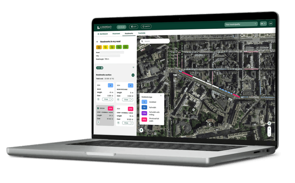
Inventory of damage and rating of your roads
Get an interactive map showing the entire condition of your network, with an inventory of the 21 types of damage and a rating of the condition of the surface and structure of your roads.
The inventory and grades can be viewed for the current year, past years and future years, on an overall view of the network or in detail by street.

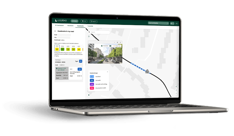
Forecasting the condition of your roads and multi-year road maintenance plan
With technology combining multifactorial mathematical models and the simulation of laws of ageing and effect, we can forecast the condition of your roads for 6 years.
Logiroad can offer you a personalized multi-year maintenance roadwork, based on preventive strategies (at the right time, in the right place) as well as technical support throughout the duration of the contract by an appointed civil engineer. Work recommendations can be viewed by type or technique, with the associated quantity and cost.
4 meetings a year

Update, modify, add, and delete works
Annual updates to the grades and maintenance plan consider the road work you have implemented and completed on the platform. Roadwork is registered in easy to filter records, giving you a detailed view of the maintenance carried out.
Add your own tailored work sections and view the progress of the recommended maintenance program, quarterly, in relation to your budget expenditure . You can also view the budget for previous years, the current year (available and spent), and future years.

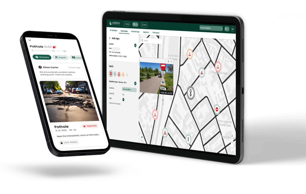
Inventory of road signs, road markings, and street furniture
Get an interactive map listing all your road signs , road markings, and street furniture.
Maintain the database with updates related to maintenance and new developments (add-ons, modifications, removals, etc.).

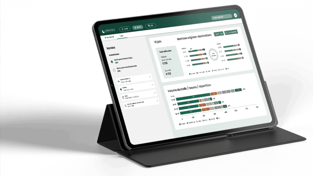
Automatically analyze your road traffic flows
AI4Traffic enables automatic analysis of vehicle traffic flows at intersections, traffic light intersections, roundabouts, and urban areas.
From permanent and temporary installations, our software allows you to analyze: Origin and destination ; Vehicle categories (pedestrians, bicycles, motorcycles, light vehicles, heavy trucks, buses) ; Speed and direction ; Crossing and counting by zones ; Counting and tracking of pedestrians on station platforms, squares, and pedestrian crossings.

360° images
An immersive 360° view, as if you were there! Enjoy a 360° image display from the date of the audit (in 5 m increments) and from Google Maps records and updates.
Logiroad Center allows for a precise visual exploration of your roadway, directly from the platform. You can inspect the condition of the roadway, outbuildings, and roadside areas without even having to move, to facilitate diagnosis and enhance decision-making.
360° images
Document management

Document management
Attach any type of document (photo, decree, invoice, plan…) to any element of your property (sign, furniture, marking, risk area, work section, path, section…) and easily find it on the interactive map of your network.
Also, take photos on site and instantly link them to the platform (photo of completed work, compliance label…).

Manage your road assets according to your own custom sector breakdown
Manage budgets, inventories, and maintenance programs across the entire network and for each sub-network.
Segmentation by geographical zones (neighborhoods, districts, municipalities, cities, divisions, agencies…) or by network types (bike lanes, bus lanes…).
For each sub-network: dedicated dashboard, condition scoring, maintenance progress tracking and forecast budget based on upcoming maintenance.
Multi-network